Figure 2. Net lake evaporation for Waubay Lake.
Note: USGS indicates that this paper is still in a state of revision. (Figure 1 not included here).
Concepts for study of hydrologic processes in northeastern South Dakota
October 12, 1999
EXECUTIVE SUMMARY
Severe impacts from the wet climatic conditions that have existed in northeastern South Dakota since 1993 underscore the need for a better understanding of the hydrology of the area. Process-oriented hydrologic studies would improve our understanding of how this area responds to climatic variability, and also would have applications to other glaciated areas in the north central U.S. These studies should focus on hydrologic fluxes between the land and the atmosphere, including precipitation and evapotranspiration, and also land-based fluxes, such as infiltration and runoff, movement of water through the subsurface unsaturated zone to the ground-water table, and interactions between ground water and lakes, wetlands, and streams. This paper presents concepts that would serve as a basis for developing a structured multi-agency research effort to improve our understanding of hydrologic processes in northeastern South Dakota. The effort primarily would emphasize applied studies including:
1) A regional frequency analysis of lakes/wetlands water levels to aid in developing appropriate design criteria for roads, engineering structures, and various facilities;
2) Precipitation and evapotranspiration studies that would aid in understanding climatic variability in the area, hydrologic responses to different climatic conditions, and likely scenarios of persistence of the current wet conditions into the future;
3) Studies of recharge to ground-water aquifers which serve as the primary water supply to much of the population in the area;
4) Studies of interactions between ground water and lakes/wetlands that would improve our understanding of lake/wetland ecosystems that produce valuable fish and wildlife resources and outstanding recreational opportunities in the area; and
5) Studies of water-quality effects of the wet conditions; the wet conditions have significantly altered the hydrologic regime of the area, and the water-quality effects are poorly understood.
The research effort could also provide an excellent opportunity to study valuable secondary issues including: use of remote-sensing techniques to evaluate hydrologic responses to climate change; biotic responses associated with effects of climatic change on wetland hydrology; and TMDL issues.
Many different groups have various management and scientific interests in the hydrology of northeastern South Dakota. These groups could contribute expertise and resources to the effort; many would also be able to leverage funding from outside sources. The current wet conditions offer a very unique opportunity to initiate a significant research effort that would have exceptional management and scientific benefits. It is crucial that funding is quickly identified so that a technical workplan can be developed to take full advantage of the opportunity.
INTRODUCTION
Wet climatic conditions have prevailed in the north central United States during much of the 1990’s. The wet period started with unusually high precipitation during the summer of 1993, which contributed to widespread flooding in the Mississippi River Basin, and has continued to the present. Impacts of the wet period have been especially severe in the Coteau des Prairies region in northeastern South Dakota (fig. 1).
INSERT FIGURE 1 HERE ...
Figure 1. Map showing eastern South Dakota and proposed study area.
Climatic variability is characteristic of continental locations like the north central United States. Changes in the balance between precipitation and evaporation lead directly to changes in lakes, wetlands, and groundwater that have prolonged consequences when climatic episodes are of extended duration.
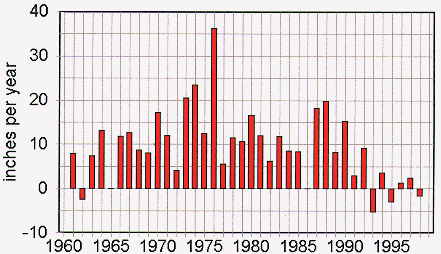
The unusual sequence of climatic conditions that has resulted in the extended wet period is apparent in figure 2, which shows estimated net lake evaporation in the Waubay Lake area (fig. 1) in northeastern South Dakota. Net lake evaporation is calculated as annual lake evaporation minus precipitation, and provides an index of change in storage in a lake system such as the Waubay Lakes Chain, which has no outlet. Both the precipitation and evaporation data used to develop figure 2 were derived from remote locations. Climatic conditions that control hydrologic components can be very localized, and accurate local measurements are needed to confidently quantify them. Therefore the data presented in figure 2 should be considered general estimates of the variability in precipitation and evapotranspiration in the Waubay Lake area. Although these data are suitable to illustrate general climatic conditions, they probably are inadequate for investigating specific hydrologic processes. The combination of high precipitation and low evaporation during the period 1993 through 1998 has been unprecedented during the period of record. The net result is that northeastern South Dakota currently is at an extreme end of the hydrologic regime, and is experiencing conditions unequalled in over 100 years.
Figure
2. Net lake evaporation for Waubay Lake.
The extreme climatic conditions must also be considered in the context of the topographic characteristics of the area to fully understand the hydrologic impacts. The Coteau des Prairies is within the Prairie Pothole Region of North America and was strongly influenced by recent glaciation. The glacial activity created a poorly developed drainage system, with numerous depressions that formed lakes and wetlands. Some of the drainage basins are closed; that is, they do not have an active outlet, and during periods when precipitation and runoff exceed evapotranspiration and infiltration, lake and wetland levels in these basins continue to rise and flood surrounding areas.
The combination of wet climatic conditions and the poorly drained topography of the area have resulted in severe hydrologic conditions. Lakes and wetlands filled quickly and have remained fully charged. The ground-water table rose significantly and has remained near the land surface. As a result, surface runoff has responded quickly to precipitation events, causing extensive flooding. Flows of the James and Big Sioux Rivers (the two major rivers draining the area) during the wet period have been consistently high (figs. 3 and 4), with above-average flows common. Numerous significant floods have occurred since 1993, in both rivers. Another significant hydrologic effect of the wet period has been to cause historically noncontributing basins to begin discharging to major stream channels, altering the hydrologic regime of the upper Big Sioux River. Effects on water-quality and streamflow characteristics that this condition has caused are unknown.
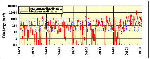
Figure 3. Mean monthly and long-term median discharge for the James River at Huron.
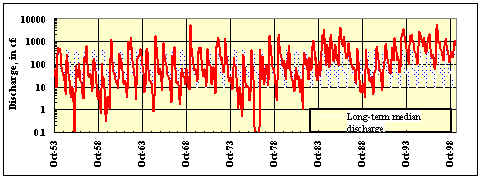
Figure 4. Mean monthly and long-term median discharge for the Big Sioux River near
Brookings.
Rises in lakes and wetlands water levels have been dramatic. The level of Waubay Lake has risen steadily, with a total increase of more than 18 ft since 1993 (fig. 5). This constitutes an increase in storage of about 350,000 acre-ft in the Waubay Lakes Chain (Niehus and others, 1999). Numerous smaller lakes and water bodies in northeastern South Dakota also have risen substantially, resulting in some of the costliest damages.
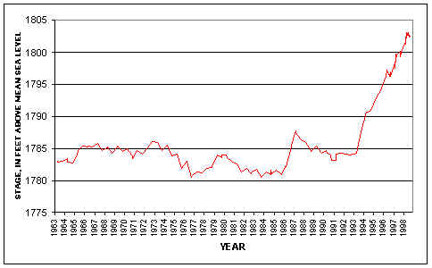
Figure 5. Long-term
water-surface elevations for Waubay Lake.
Rising lake levels and flooding conditions in the region have resulted in substantial damage to public and private property including roads, recreational facilities, farmsteads, and homes, as well as loss of thousands of acres of valuable farmland. Flooding of the Big Sioux River at Watertown in recent years has resulted in extensive damage and continues to be a major concern, partly because of uncertainties of the hydrology of the upper Big Sioux River. It has been estimated that in excess of $70 million in federal assistance has been dedicated to alleviating the effects of the wet period. State and local expenditures have also been extreme.
Not all of the effects of the situation are considered negative. Fish and wildlife populations have exploded, resulting in establishment or revival of excellent sport fisheries, and an increase in wildlife populations associated with wetland areas. Recreational opportunities in the area have increased, primarily in the form of fishing and hunting activities. The tourism industry in the area has greatly benefited from the wet conditions.
A major uncertainty in evaluating future effects (both positive and negative) of the wet period relates to how long the conditions will persist. The U.S. Geological Survey recently completed a frequency analysis for the Waubay Lakes Chain (Niehus and others, 1999). Results indicate that there is a high probability that relatively high lake levels will be sustained for many years into the future. As an example, 16 years of prolonged dry conditions, similar to those that occurred during 1969-76, would not return Waubay Lake to pre-1993 levels. The frequency analysis used a statistical approach that was based on remote precipitation and evaporation data and on historic records of lake levels for the Waubay Lakes Chain. The best data available were used in the study; but, the climatic variables, which are highly dependent on localized conditions, had to be estimated using remote data. These climatic data were critical to the study results, and the magnitude of the uncertainty due to the remote estimates is largely unknown. The analysis contributed much information for developing strategies to deal with economic effects of the inundation based on currently available information. However, the study was restricted to only one major subbasin, and also did not address hydrologic processes related to the rise in lake levels that can be applied to a broader regional area. Water bodies with different characteristics than the Waubay Lakes Chain undoubtedly will respond differently to future climatic conditions. Detailed information regarding the hydrologic processes involved would be beneficial for improving probability estimates on a regional scale, and for predicting short-term responses to hydrologic conditions.
NEED FOR STUDY
The scientific community in the north central United States considers the current climatic and hydrologic conditions an unparalleled opportunity to provide new knowledge that can be applied to the immediate flooding problems while building an understanding of the hydrologic system that will provide benefits in the future. Research efforts should focus on a structured study of key hydrologic processes with emphasis on practical applications to aid in planning and water management.
Damages sustained during the extended wet period highlight the need for a structured study of hydrologic processes in the region. Existing data were inadequate to effectively deal with flood conditions. Roads were raised, only to be submerged again. Numerous farmsteads were flooded and thousands of acres of valuable cropland were lost from production. Although some of the damages were unavoidable, additional data are needed for efficient planning and water management in the future.
Climatic and hydrologic variability is subject to both random and cyclical influences, which complicates planning activities. To establish a suitable statistical basis for estimating the frequency of hydrologic events, data must be collected under a wide range of conditions. The current conditions at the extreme end of the hydrologic spectrum provide an opportunity to collect data and perform research that will incorporate a wide range in hydrologic variability.
Topographic and geologic characteristics of the Coteau des Prairies offer a unique opportunity to study various hydrologic processes at regional and local scales, under a variety of conditions. The Waubay Lakes Chain (a closed basin lake system in northeastern South Dakota) would be especially appropriate for regional studies of evaporative processes and fluxes, because these lakes serve as a terminal evaporative system for a closed-basin area of about 409 square miles. Other nearby areas could be appropriate for related studies at local scales, such as ground-water interactions with wetlands, and surface recharge to ground-water aquifers. These related studies would be timely because of the similar wet conditions and the similar processes, which include evaporative fluxes and fluxes from the land surface to the water table.
RELEVANT HYDROLOGIC PROCESSES
There are several basic hydrologic processes and fluxes that must be quantified and understood for efficient planning and water-management activities. Precipitation is the basic source of water to the earth’s surface; however, a variety of conditions influence the fate of atmospheric water reaching the earth. Precipitation can fall on water bodies, run off directly from the land surface into water bodies, or infiltrate the land surface. A wide variety of hydrogeologic conditions exist that govern the fate of water precipitated on the land. Variation in permeability of deposits at and near the land surface is of paramount importance. Near-surface permeability has a pronounced effect on the infiltration rate, which affects runoff, surface storage (wetlands or lakes), soil-moisture storage, and recharge to underlying aquifers. Permeability of underlying deposits also can affect surface storage and interactions, as a result of either recharge from, or discharge to wetlands and water bodies. Evapotranspiration controls the flux of moisture returned to the atmosphere and is one of the primary factors governing the persistence of wet conditions. Thus, complex interactions between the atmosphere, the earth’s surface, and subsurface features have a profound effect on availability, storage, and movement of water.
The processes that could result in either further increases or decreases in lake and wetland levels in northeastern South Dakota generally are understood, but poorly quantified in the area. The relative magnitude of the processes and the rate at which they occur currently is based on estimates derived from indirect measurements made at remote locations. Measurements of the rates of evaporation and changes in surface and subsurface water levels have not been measured in the glacial topography of the Coteau des Prairies in a systematic way that enables impacts of extreme climatic conditions to be quantified in scientific and economic terms.
NEEDED RESEARCH ACTIVITIES
Various process-oriented studies would have broad applicability to a variety of planning and water-management needs. Primary and secondary research topics, as well as a general summary of data-collection activities for the types of studies that are needed are outlined below:
* PRIMARY RESEARCH TOPICS
* SECONDARY RESEARCH TOPICS
* DATA-COLLECTION ACTIVITIES
INTERESTED PARTIES
There is a need for a structured effort to take full advantage of the unique research opportunities while also optimizing use of available resources. An effort of the magnitude envisioned would require many entities to contribute both resources and manpower. Numerous groups and agencies are interested in developing a better understanding of the hydrology of northeastern South Dakota for both management and scientific purposes (fig. 6); many of these groups are already addressing specific issues in the area and may be able to leverage research funds from outside sources.
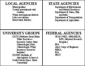
Figure 6. Potential interested groups and agencies.
CONCLUSION
The purpose of this concept paper is to provide a common basis for organizing and funding an investigation that will provide direct benefits to South Dakota citizens by improving the knowledge base for decision making during hydrologic conditions that have not existed in at least 100 years. This project cannot be done successfully unless both policy and science leaders cooperate to develop a common understanding of the relevant environmental factors coupled with physical, economic, and timescale considerations of various water-management alternatives. Accordingly, this proposal is a concept level paper that outlines the data and research needs for developing a quantitative understanding of the hydrologic conditions to be able to reasonably anticipate what climatic variability may bring us in the future. The paper also outlines the practical benefits to local, state, and regional entities, and it identifies the scientific concepts along with the agencies and groups who could provide the human and material resources required for a systematic investigation. It is crucial that funding sources are quickly identified so that a technical workplan can be developed to take full advantage of the opportunity.
REFERENCES CITED
Niehus, C.A., Vecchia, A.V., and Thompson, R.F., 1999,Lake-level frequency analysis for the Waubay Lakes Chain, northeastern South Dakota: U.S. Geological Survey Water-Resources Investigations Report 99-4122, 166 p.
Return to "Info on Oct. 7, 1999 SD NASA EPSCoR Meeting" website